
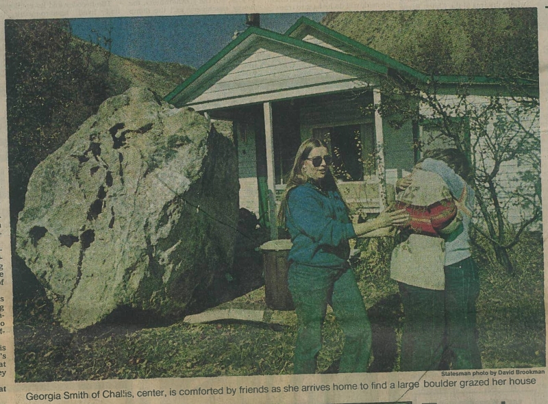
1984 Salmon Ice Jam Floods
December 1983 and January 1984 brought unusually cold weather to Lemhi County and the town of Salmon, Idaho where the Salmon and Lemhi rivers meet. Low temperatures were consistently in the negatives during the latter half of December—the coldest temperatures reached -29°F in town and -54°F higher up in the Salmon River basin—and two ice jams formed along the river.
An ice jam refers to a build-up of ice that blocks the river’s flow causing the water upstream to slow down and rise higher. The rising water floods surrounding areas when the water level exceeds the channel or levee height. Flooding can also occur when a jam fails or breaks apart, rapidly releasing upstream water and creating a situation similar to a flash flood downstream. In the Salmon River, cold temperatures allowed the formation of frazil ice, a slushy ice that originates in turbulent open waters. Pieces of frazil ice grouped together to make large ice floes which eventually blocked the channel flow at a constriction known as Dump Creek. The river then began freezing progressively further upstream.
The first jam on December 22 broke apart on December 27 and the second jam on December 29 broke apart on December 31. The Bureau of Disaster Services (BDS) reported that this ice jam reached 22 miles in length. Warm weather in early January prevented the formation of new ice jams until January 15 when temperatures plummeted. With temperatures at or below zero degrees again, an ice jam 30 miles long stretched along the Salmon River into the town to the confluence with the Lemhi River.
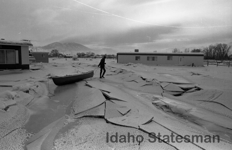
As water from the Lemhi River encountered ice rather than a flowing channel, it slowed down, rose higher, and froze up to a mile and a half upstream from the river’s mouth. This marked the start of an ice jam along the Lemhi River. Upstream the Lemhi continued to rise, but with ice blocking its path the river repeatedly overtopped its banks and flowed into the northern part of the town of Salmon on January 19, 21, 23, and 28.
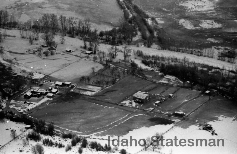
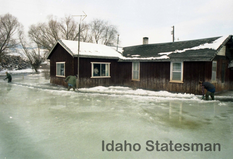
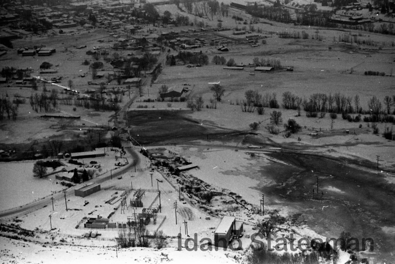
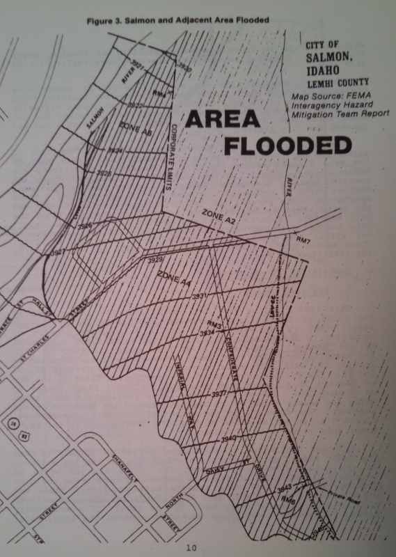
Water flooded the northern part of the town including North St. Charles Street, Confederate Drive, North Daisy Street, and Imperial Drive (see map; insert link to image titled SalmonMap.jpg) causing 325 people to evacuate their homes. Evacuations began on Thursday January 19 but some residents chose to remain in their homes. One resident stayed citing concerns that evacuating would leave their home vulnerable to vandalism similar to what was seen during a 1962 flood.
In a story in the Idaho Statesman, another family claimed they thought their home would be safe since it was “on a little higher ground,” but at 1:30 a.m. the family heard water “rushing against the house.” As water began coming into the home, they remarked that “water under the rug was like walking on a water bed (sic).” The family spent 10 hours in their home before Search and Rescue found them. Downed telephone lines made calling for help impossible; the telephone company stated they lost 50 lines during the flooding. The power company experienced no outages.
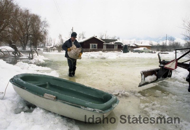
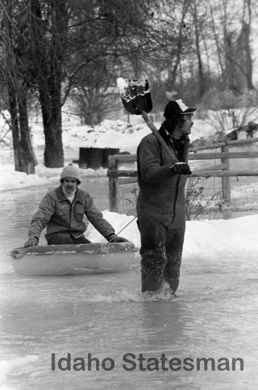
The Post-Register reported that “residents had to be evacuated without their belongings, some carried to safety, clinging to front-end loaders.” Three people suffering from exposure to the cold were transported to the hospital. About 50 residents were rescued by Salmon Search and Rescue. After initial flood levels dropped, some residents began returning to check on their homes against official recommendations. Radio stations carried pleas from officials for people to refrain from returning to evacuated areas. They worried that sudden, renewed flooding would place returning residents in danger, causing Search and Rescue to respond a second time.
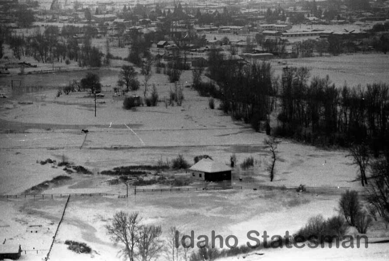
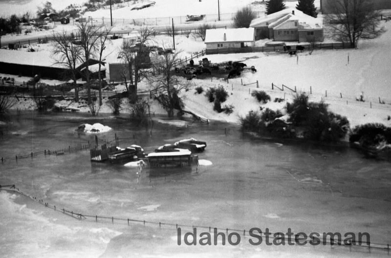
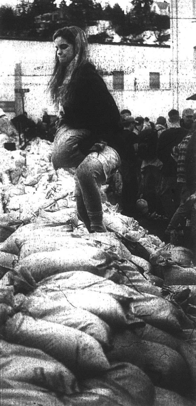
When the floodwaters receded, residents found nearly 3 feet of ice inside their homes and 5 feet of ice outside. The subzero temperatures left the town literally encased in ice. The BDS and Department of Water Resources reported that 81 residences sustained damage from the flooding including mobile homes and an apartment complex. Also damaged were “two oil companies, a beer distributor, a river tour business, a horseshoeing business, [and] a sawmill.” Flooding impacted 3,000 acres of land in and downstream of the town of Salmon and 1,000 acres of upstream agricultural land. A total of 200 acres of the town flooded and over 500 volunteers directed water away from other parts of town with 10,500 sandbags, thousands of which were provided by the BDS.
Governor Evans declared the flooding a state disaster and almost immediately people began wondering how the state would afford the clean-up costs. With state emergency funds already promised to help Challis and Mackay recover from the Borah Peak Earthquake in October 1983, little funding remained for flood recovery. The Associated Press reported that “the Idaho Senate passed a bill that would add $250,000 to the governor’s diminished emergency fund.” A drop in the bucket of the total cost, Gov. Evans requested a presidential disaster declaration which President Reagan granted on February 16, 1984. The final price-tag on recovery from the Salmon floods amounted to $1,300,000: $432,957 in public assistance, $613,044 in private assistance, $156,900 in administrative costs, and $91,957 in miscellaneous costs.


References:
- Idaho Office of Emergency Management. (2013). State of Idaho Hazard Mitigation Plan 2013.
- Idaho Department of Water Resources & Idaho Bureau of Disaster Services. (1985). Hazard Mitigation Report: Lemhi County and City of Salmon, Idaho FEMA DR-697 declared February 16, 1984 (DOW & BDS Publication 4/85-250). Boise, ID.
- Selected articles from the Idaho Statesman, Post-Register, and Recorder-Herald published January and February 1984 and retained in the IOEM document storage.
- S. Kiser, personal communication/memo, January 27, 1984.
1996 Panhandle Floods
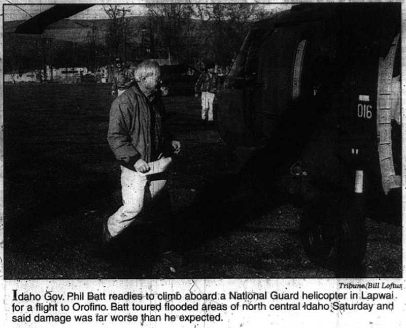
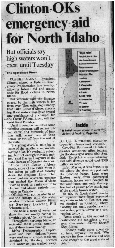
In February 1996, the Pacific Northwest experienced significant flooding due to a “rain-on-snow” event combined with ice jams in the rivers. Temperatures hovered just above zero degrees at the end of January forming ice along many rivers, and deep snow blanketed Idaho’s panhandle. However, the start of February brought warmer temperatures and four days of heavy rains. As warm temperatures melted ice and rain fell on snow, the rivers of northern Idaho rose to near record heights. The most severe flooding centered on the Coeur d’Alene River basin, St. Joe River basin, and the Palouse, Orofino, and Lapwai creeks. Flooding began on February 6, peaked on February 9, and continued until February 23, but its effects would be felt for much longer. On February 11, President Clinton declared 10 counties (Boundary, Bonner, Kootenai, Shoshone, Benewah, Latah, Nez Perce, Lewis, Clearwater, and Idaho) and the Nez Perce Indian Reservation a federal major disaster area.
According to the National Oceanic and Atmospheric Administration (NOAA), the Coeur d’Alene and St. Joe rivers reached their second highest crest ever recorded. The flood stage near Cataldo, along the Coeur d’Alene River, is 43 feet; the flooding in February 1996 reached a height of 51.62 feet. Only the January 1974 floods surpassed this level rising to 58.23 feet. NOAA considers any event higher than 50 feet a major flood stage.
The Idaho Statesman described the scene well in a February 11 article which referred to the panhandle as a “sodden landscape of blown-out highways, wrecked homes, rock slides and mud.” Flooding caused widespread damage and evacuations throughout the Pacific Northwest. The Idaho Statesman reported that flood waters displaced 30,000 throughout Oregon, Washington, Idaho, and Montana. An estimated 2,500 people evacuated their homes in northern Idaho.
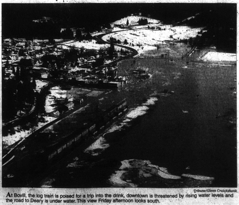
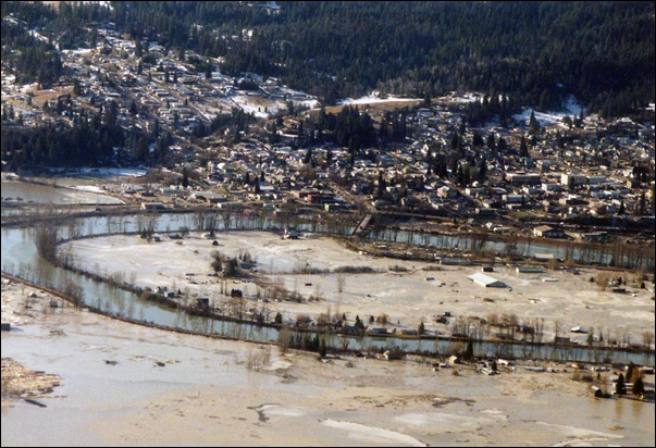
In St. Maries, melting ice jams contributed to the flooding. The St. Joe River broke through the levees that surrounded and protected the town leaving only the roof above water on some homes. Overall, the flooding damaged over 100 homes in the town.
In Cataldo on Wednesday February 7, officials anticipated significant flooding from water released by a breaking ice jam. Officials evacuated the town, but the waters didn’t come. Over the next few days, as the Coeur d’Alene River continued to rise, residents returned and fought to save Cataldo from the encroaching flood by blocking the water with sandbags. In the morning on Friday February 9, the National Guard pulled troops from Cataldo out of concern for their safety. Even after the National Guard left, residents continued working, but at 2 p.m. they could no longer hold back the flood. Two hundred people evacuated as the water surged into town.
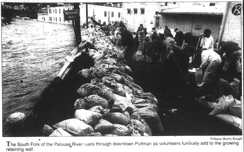
With towns throughout the panhandle at risk, hundreds of volunteers worked building sandbag walls. In Clearwater County, minimum security inmates at the Idaho Correctional Institution in Orofino joined the effort to build sandbag levees.
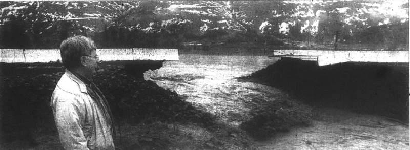
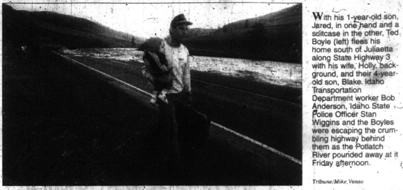
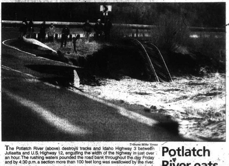
Hundreds became trapped as mudslides and high water made roads impassable. Some stranded residents needed to evacuate and were rescued with boats, all-terrain vehicles, and helicopters. Highways and local roads throughout the panhandle closed including Highway 12—the major east-west artery—and Highway 95—the major north-south artery. In addition to closing roads because of mudslides, part of highway 12 closed when the river tore out a 26-foot culvert and the 40 feet of road above and surrounding it. A woman driving on Highway 12 outside Lewiston witnessed the Cottonwood Creek bridge collapse. The Lewiston Tribune quoted her, “I heard a large pop and felt my dad’s truck, a big new Ford Supercab, kind of lunge down. I looked in the sideview mirror and saw the lane gone behind me.” In Moscow, officials reported that “residents blew through barricades and each other’s yards to get to homes.”
Schools throughout the panhandle closed during the flooding. Unfortunately, in Lapwai, schools failed to close before many roads closed. Students were separated from their families and telephone outages made it impossible to contact some families. Around 12 students had to stay with school staff or other family members in accessible areas.
The University of Idaho stayed open until February 9 when the university canceled classes. Campus buildings began flooding and sewage began backing up. The university even put out a request to “restrict use of restroom facilities as long as possible.” Water quality became a significant concern as flood waters mixed with water at wastewater treatment facilities across northern Idaho. Orofino officials became concerned that the forced closure of intake pumps and a limited reservoir of water would force the city to “pump directly into the system and issue a boil water notice.” On February 9, Clearwater County issued an order for people to boil water before use. In Boville, officials began adding chlorine to reservoirs as floods overran sewage lagoons.
Another host of problems arose as floodwaters poured into Coeur d’Alene Lake. The lake rose significantly during the flooding—to eight feet above the summertime average—and prevented upstream areas from draining as the rains came to an end. The Idaho Statesman reported that “until [the lake crests], communities some 20 miles upstream will remain under water and hundreds of families will remain out of their homes or cut off from the rest of the state.” The newspaper also noted that the river traveled nearly a mile from the channel in some areas and that as the lake drained, flooding was possible downstream along the Spokane River. Later reports from the U.S. Geological Survey revealed that the 1996 flooding washed large amounts of trace-metal laden sediment into Lake Coeur d’Alene. Silver, lead, and zinc transported to the lake stemmed from extensive historical mining activity in the area.
Not all reports during the flood were accurate. On the morning of February 8, radio broadcasts reported incorrectly that the Winchester Dam on the Lapwai Creek had failed. The false broadcast left officials rushing to check on the dam which had no damage from the floods. The levels of the Winchester Reservoir, however, did come close to overtopping the dam. Water reached within inches of the top of the dam.
The final cost of the flood damage reached $28,030,398. This includes $22,635, 325 in public assistance, $71,639 in private/individual assistance, $301,081 from the National Resource Conservation Service, and $5,022,353 in hazard mitigation grants. University of Idaho alone sustained $1.6 million in damage.
References:
- Idaho Office of Emergency Management. (2013). State of Idaho Hazard Mitigation Plan 2013.
- National Oceanic and Atmospheric Administration National Weather Service. (2014). Coeur d’Alene River at Cataldo. Advanced Hydrologic Prediction Service. Retrieved from https://water.weather.gov/ahps2/hydrograph.php?gage=ctli1&wfo=otx
- National Oceanic and Atmospheric Administration National Weather Service. Flooding in Idaho. Retrieved from: https://www.weather.gov/safety/flood-states-id
- Selected articles from the Idaho Statesman and Lewiston Tribune published February 7 – 12 1996. United States Geological Survey. (1996). Water-Quality Data Collected During Floods in the Coeur d’Alene River, Northern Idaho, February 1996. (USGS Fact Sheet FS-219-96).